| |
the course
Course Description - Directions - Aerial View
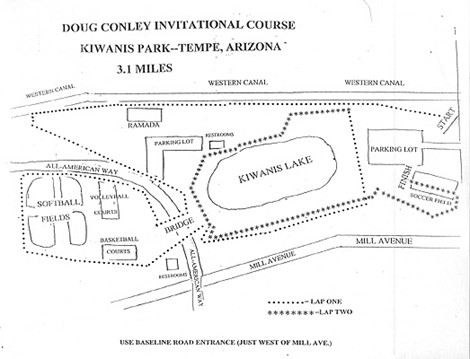
Course Description
Tempe’s premier 125 acre park offers amenities and activities that include a 13 acre lake, fishing, boat rentals, sand volleyball courts, softball, soccer fields, recreation center, and children’s playgrounds.
The Start is at the most Northwest part of the park starting on grass and leading to the Western canal bank which is dirt for ¾ mile, then switching to sidewalk that leads to under the bridge at the 1 mile mark. The course then loops around the softball fields and sand volleyball courts to under the bridge again then suddenly climbs 25m up All American hill that leads to the 2 mile mark at the Northwest side of the lake. After the 2 mile mark there is a slight decline that leads to a small hill that begins the final loop around the lake. At approximately 2.6 miles there is a fairly steep 40m hill, Ramada Hill, that takes you up on the ridge then downhill towards the lake and back up a 20m hill for the final ½ mile of the race. After the turn at the most Northeast part of the park the Finish is 150m straight away across a soccer field.
Course has varied terrain that includes grass, dirt, sidewalks, side incline, slight down hill decline. What makes the course challenging is that it is difficult to settle in a consistent pace with the varied terrain.
General consensus of course’s difficulty is Medium- Hard.
Course is certified 3.1 miles
Course is Fan Friendly.
Course Record Boys - Ken Cormier Douglas 15:46.20 2004
Course Record Girls - Mel Lawrence Reno 17:42.00 2004
|
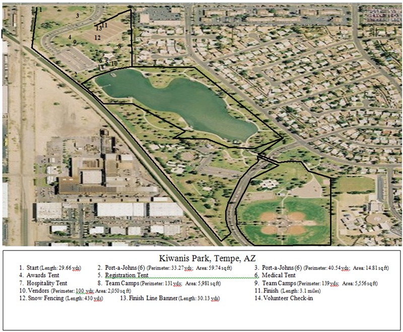
Aerial View
Directions to Course - Kiwanis Park, Tempe AZ From Sky Harbor International Airport (PHX) Go East on Sky Harbor Blvd Merge onto AZ-153 S. toward AZ-143/ I-10 Take the University Dr. exit on the left, Turn slight left onto University Dr. Merge onto AZ-143 S Merge onto I-10 E / US-60 E via Exit 1A, toward Tucson Merge onto US-60 E. via Exit 154 towards Mesa - Globe Take the Mill Ave exit- Exit 173 Turn Right onto S. Mill Ave Turn Right onto W. Baseline Rd Turn Left into Park From The South (Tucson) North onto I-10 towards Phoenix Take the Baseline Rd exit , Exit 155 Turn Right onto W. Baseline Rd Turn Right into park just after railroad tracks, 1.5 miles from I-10 From The North (Flagstaff) I-17 South towards Phoenix Merge onto I-10 E /US-60 E via the exit on the left towards Globe / Tucson Merge onto US-60 E via exit 154 towards Mesa / Globe Take Mill Ave exit- Exit 173 Turn Right onto S. Mill Ave Turn Right onto W. Baseline Rd. Turn Left into Park From the East West onto US-60 Take Mill Ave exit- Exit 173 Turn Left onto S. Mill Ave Turn Right onto W. Baseline Rd. Turn Left into Park
NTN Southwest home page
|